
Sat, Sep 06, 2025
8:00 AM - 10:00 AM
Join Blaine, Jan and Cal for an easy walk 1-5 miles depending on the groups' interest.
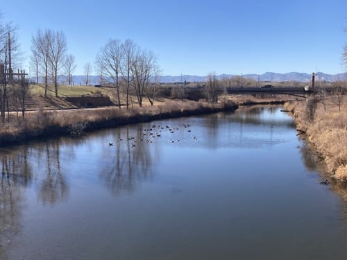
Description: This area is another urban treasure. Multiple trails traverse the area
along the river and around several ponds. It has been discovered and, understandingly,
become popular. We’ve set our outing for an off-peak time and we will adjust our path
to our group’s needs and interests. We’ll do 1-5 miles depending on the group’s
interests. For our wheelchair participants or those wanting a short outing, we’ll start with
a nice loop going to the river and then around Eagle Watch Lake and its wildlife viewing
blind – a loop just under a mile. For those wanting to continue, we’ll loop go back to
river for an out-and-back walk along the river up to another 2-3 miles roundtrip.
Where: The Mary Carter Greenway Trailhead is in South Platte Park barely north of
C470 on west side of the river. The Park’s entrance is where the east-west running
Chatfield Avenue bends northeast to become the South Platte Canyon Drive.
If coming from the East on C470: take the Platte Canyon exit. At the roundabout right
after the off-ramp take the 1 st exit to go NE on Platte Canyon. Take the next right – it’s a
very sharp hairpin curve. You’ll quickly see a sign that says you’re entering South Platte
Park and, above it in smaller letters, Mary Carter Greenway. Follow the road (there are
no possible turns to take before coming to the first of two parking areas. We’ll meet
here because it’s bigger than the one next to the river and it has nicer restrooms.
If coming from the West on C470: take the Wadsworth exit (there is no exit from east-
bound C470 to Platte Canyon). Turn right at the first light, and go east on Chatfield to
the roundabout. Take the second exit to continue on Chatfield which then becomes
Platte Canyon. As above, take the next right – it’s a very sharp curve. You’ll quickly
see a sign that says you’re entering South Platte Park and, above it in smaller letters,
Mary Carter Greenway. Follow the road (there are no possible turns before coming to
the first of two parking areas. We’ll meet here because it’s bigger than the one r next to
the river and it has nice restrooms.
If coming from the east or the west on Ken Caryl Road: turn South at the light at Platte
Canyon and take the second left it is across from Depew St. You’ll have to immediately
turn right and you’ll quickly see a sign that says you’re entering South Platte Park, and,
above it in smaller letters, Mary Carter Greenway. Follow the road (there are no
possible turns to the first of two parking areas. We’ll meet here because it’s bigger than
the one next to the river and it has nice restrooms.
Plus Code: HX93+9VQ
Enter this code into Google Maps
Entrance fees: No (We’ve timed our outing to avoid the peak season and any
requirements to pay for, or reserve, parking.)
Distance: We’ll start with a 0.8 mile loop and then continue with an out-and-back or
loop based on the groups interests and abilities.
Elevation gain: Negligible
Dogs allowed: TBD
Toilets at the trailhead: Yes
Be sure to bring: Water, sunscreen, hat and desire to get out and enjoy nature
Hike Leader Number: 720-392-3421 – Blaine’s cell --- Please call or text if you need
to cancel or if you are running late.
Event roles
8:00 AM - 10:00 AM
Filled
Hike/Walk Participant
8:00 AM - 10:00 AM
Filled
Hike/Walk Participant
8:00 AM - 10:00 AM
Filled
Hike/Walk Participant
Need Reminders?
If you sign up, we will send you an email or SMS text message reminder around 24 hours before your sign-up.